Snake River
Plain -Tributary Basins
Basins tributary to the Snake River in the SR3 study area cover parts of Idaho,
Wyoming, Utah, Nevada, and Oregon. The Snake River from Jackson Lake, Wyoming
to Brownlee Dam, on the Idaho-Oregon border, is nearly 700 miles long. The tributary
basins, combined with the east and west parts of the Snake River Plain, drain
more than 72,000 square miles (46,000,000 acres). Depending on the scale or detail
with which the Snake River drainage system is examined, there are at least 60
separate streams or drainages that connect to the main stem of the river or at
least deliver water to the Snake River Plain (Kjelstrom, 1986; Peterson, 1988).
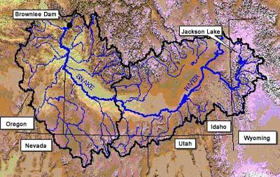 Jackson Lake
is the beginning of the Snake River. The lake is nestled at the base of the
Teton Mountains within Grand Teton National Park About 15,300 square miles
of the study area is associated with the Snake River Plain with an additional
56,000 square miles within the hydrologic units that extend up the tributary
basins.
Jackson Lake
is the beginning of the Snake River. The lake is nestled at the base of the
Teton Mountains within Grand Teton National Park About 15,300 square miles
of the study area is associated with the Snake River Plain with an additional
56,000 square miles within the hydrologic units that extend up the tributary
basins.
Water in the Snake River begins its journey flowing south through Jackson Hole,
as shown in photo to left.. The major tributaries in this region include
the Gros Ventre River, Hoback River, Greys River, and the Salt River.
More than twenty tributary streams feed into the Snake River in the eastern
portion of the Snake River basin. The larger tributaries in this area include:
Henrys Fork, Teton River, Falls River, Big Wood River, Blackfoot River, Big
Lost River, and Portneuf River. The Snake River drops in elevation from more
than 5,015 feet on the eastern side of the plain, to about 2,100 feet on the
western edge near Weiser, Idaho.
The most downstream reach for this study, the Middle Snake-Boise sub basin,
extends from King Hill to Brownlee Dam and includes the western Snake River
Plain. The western Snake River Plain is about 50 miles wide and 145 miles long
(Newton, 1991). The major tributaries in this region include: Payette River,
Boise River, Weiser River, Owhyee River, Bruneau River, Malheur River, Powder
River, and Burnt River.
Information supplied by Idaho
Water Resource Research Institute, University of Idaho December 1998
Authors: Dr. Gary Johnson, Donna Cosgrove, and Mark Lovell.
Graphics: Sherry Laney and Mark Lovell
All State of Idaho images and graphics created with GIS files obtained through
Idaho Department of Water Resources Public Domain GIS unless otherwise noted.
Source
Information